There are several miles of trails within the West Duwamish Greenbelt. The trail conditions vary depending on how well the trail is maintained or used. The trails that are within park boundaries are typically better maintained. There are also “social” trails that urban hikers have made to connect trails and points of interest. Several trails have also been created for restoration activities. Most of the trails are in the northern portion of the greenbelt north of Highland Park Way, but there is also a trail network to the south at Westcrest Park.
New Trails Map
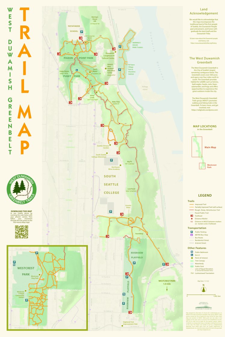
This stretch of woods in West Seattle is teeming with life, full of trails, and lots of room for roaming. But, for years, a seemingly impenetrable facade of overgrowth and a lack of knowledge of the trail system have kept many people out. A new trails map will unravel the mysteries of the trail system.
This new trail map includes a QR code so you can download the map to your mobile device. Scan the code with your phone’s camera to use the free Avenza Maps App, which will allow you to follow your movement through the trail system on your phone. You can also download the PDF version if you want to print your own.
The West Duwamish Greenbelt is Seattle’s largest remaining contiguous forest covering 500 acres spanning more than four miles north to south. There’s a whole network of trails that one can traverse from the Duwamish Longhouse to Riverview Park and down to Highland Park Drive passing the South Seattle College campus, Puget Park and Pigeon Point Park.
The new map reflects the growing trail network and connections with the community. After more than six months of work, hundreds of volunteer hours and the patient consultation and craft of a West Seattle cartographer, the map is ready to guide users through the greenbelt.
The West Duwamish Greenbelt Trails Group has been working in partnership with the Duwamish Tribe to activate the park and draw people to the vast open space. In April, the group won a $5000 volunteer match grant for the mapping project through the City of Seattle’s Small Sparks Fund.
Previous iterations mapped the trails, but this is the first time a geo-located map has defined the greenbelt newly created trails added in and an overall revision of the legacy trails represented.
Matt Dressler, Cartographer and GIS Analyst at Mountains To Sound GIS in West Seattle, crafted the map from several sources of data including city and state topo and lidar maps along with GPS tracks recorded by WDGT members. Dressler knew the greenbelt existed but didn’t know the many features hidden behind the lush curtain of forest. “I was surprised at the extent of the existing trail system in the Greenbelt. Another learning for me working on this map was the range of trail types in the Greenbelt–from easier “improved” trails to more steep and challenging trails. The map identifies these trail types so visitors to the Greenbelt can choose those trails most suited to the experience they are looking for.”
Craig Rankin, WDGT group member and Co-Chair of the Highland Park Action Coalition, pointed out that the trails are fun and challenging, but conditions and quality of the various trails can really vary based on time of the year, moisture and terrain. “Use common sense when choosing your personal level of risk. Hike with a friend, start with the Parks built gravel trails and branch out only with knowledge of risks at hand. Slipping is a risk on all of the more adventurous trails. Poles can help during wetter conditions, but logs and planks over creeks, and slippery mud need to be hiked with caution.”
Hikers and walkers can traverse the slopes of the greenbelt and find Lost Pond. Or, they can meander along streams in Puget Park. A set of granite steps from the Holly Street trailhead may challenge or delight hikers depending how fast you can climb them, but luckily a granite bench at the top gives the intrepid adventurer a place to rest and a view of the Duwamish valley, in season.
Throughout the map, users will find names of different areas in both English and Lushootseed, the language of the Coast Salish. WDGT worked with Ken Workman of the Duwamish Tribe to identify recognizable physical characteristics of distinct areas in the greenbelt and name them for easy identification. Seven Cedars–c̕úʔkʷs x̌payʔ–is a favorite spot long known by many Pathfinder students as a place where Fluffy and Sleepy, two Barred owls, reside.
Craig Rankin sees the map project as a big step forward to making the space more inviting: “Healthy communities are connected, walkable, and cared for. After over a century of challenges within the West Duwamish Greenbelt including dispossession of the Duwamish Tribe, deforestation, mining, landslides, and toxic dumping, local stakeholders have made great progress in restoring the health of the largest remaining forest in Seattle.”
The greenbelt is making a comeback with life bristling in the canopy and on the forest floor. On any given day, or night, an array of animals from coyotes and fox to Barred owls and Redtail hawks to salamanders and frogs might be seen. Birders from around the region can be spotted in the greenbelt waiting for that unique photo opportunity with fledgling owls or raptors on the hunt.
Ongoing preservation and reforestation is happening thanks to work from the Duwamish Tribe, WDGT, Green Seattle Partnership, Delridge Neighborhoods Development Association, Washington Trails Association volunteers and neighbors throughout Seattle.
“The biggest thing about having a truly useable map of the greenbelt is the ability to invite people in to explore this amazing place,” said Matthew Clark, WDGT group member. “We want to help build community, and this is one step to help do that here in West Seattle. We hope more people come out to walk, hike or run these trails.”
Matt Dressler feels the mobile friendly feature of the new map will entice new visitors. “I hope the map encourages people to visit and explore the Greenbelt by providing the information they need to plan, access and navigate the trail system. For visitors comfortable using their mobile devices for navigation, the map has a QR code so it can be downloaded and will use the phone’s GPS to show people their current location in the trail system as they move around.”
Other Maps
 The Seattle Trails App shows you where all the official Seattle Parks trails in Seattle are. This App has been built as an open-source project by volunteers to improve the experience of getting outdoors in Seattle. It is a collaboration between Seattle Parks & Recreation Department, Seattle Trails Alliance and volunteer software developers.
For several years, Alan Robertson walked the trails in the West Duwamish Greenbelt and wrote about it at his blog Walking Riverview. Alan and Lynn have moved out of the area, but the work he did documenting trails and the history of community involvement in the greenbelt has been generously shared with the WDGT group on this website.
